The FOOTPRINT Tools: FOOTPRINT SUGAR
 SUGAR
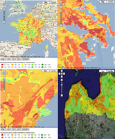
stands for SUrface water / GroundwAter contRibution index, and is an innovative index
which idemtifies whether water falling on a particular zone mostly contributes to
groundwater recharge (i.e. infiltrating areas) or to discharge to surface water. FOOTPRINT
SUGAR is very data-parsimonious and relies on measured data only. Information has been
compiled for the whole of Europe and is distributed in the form of national datasets on
this web site.
SUGAR
stands for SUrface water / GroundwAter contRibution index, and is an innovative index
which idemtifies whether water falling on a particular zone mostly contributes to
groundwater recharge (i.e. infiltrating areas) or to discharge to surface water. FOOTPRINT
SUGAR is very data-parsimonious and relies on measured data only. Information has been
compiled for the whole of Europe and is distributed in the form of national datasets on
this web site.
FOOTPRINT SUGAR has many potential applications in
hydrology and in the field of risk assessment for pollutants (of agricultural or
industrial origin).
For a list of frequently asked questions complied by the
developers of FOOTPRINT SUGAR, download the pdf  .
.
FOOTPRINT SUGAR data can be accessed in a number of
formats, which can be downloaded below:
- jpeg this is a standard format for pictures.
- pdf this is a standard format for viewing documents. Adobe
Reader can be downloaded for free from here
 .
.
- kmz this allows you to view the information in
GoogleEarth. GoogleEarth can be downloaded for free here
 .
.
In addition GIS files for ArcGIS or MapInfo can be
requested by contacting the team at aeru@herts.ac.uk.
EU 27
|
jpeg |
pdf |
Google
Earth |
 Austria Austria |
 |
 |
 |
 Belgium Belgium |
|
|
|
 Bulgaria Bulgaria |
|
|
|
 Cyprus Cyprus |
- |
- |
- |
 Czech Republic Czech Republic |
|
|
|
 Denmark Denmark |
|
|
|
 Estonia Estonia |
|
|
|
 Finland Finland |
- |
- |
- |
 France France |
|
|
|
 Germany Germany |
|
|
|
 Greece Greece |
|
|
|
 Hungary Hungary |
|
|
|
 Ireland Ireland |
|
|
|
 Italy Italy |
|
|
|
 Latvia Latvia |
|
|
|
 Lithuania Lithuania |
|
|
|
 Luxembourg Luxembourg |
|
|
|
 Malta Malta |
- |
- |
- |
 Netherlands Netherlands |
|
|
|
 Poland Poland |
|
|
|
 Portugal Portugal |
|
|
|
 Romania Romania |
|
|
|
 Slovakia Slovakia |
|
|
|
 Slovenia Slovenia |
|
|
|
 Spain Spain |
|
|
|
 Sweden Sweden |
- |
- |
- |
 United Kingdom
 |
|
|
|
Acceding countries
|
jpeg |
pdf |
Google
Earth |
 Croatia Croatia |
|
|
|
 Former Yugoslav Republic of Macedonia Former Yugoslav Republic of Macedonia |
|
|
- |
 Turkey Turkey |
- |
- |
- |
Non-EU countries
|
jpeg |
pdf |
Google
Earth |
 Switzerland Switzerland |
|
|
|
 Norway Norway |
- |
- |
- |
 Iceland Iceland |
- |
- |
- |